Dialogue April-June, 2010, Volume 11 No. 4
Diversion of Brahmputra Water to North China
Yogendra Narain Roy*
Water is life’s matter and life is not possible without water. Water is a resource of nature. But it is not an infinite resource. Only 1.5% of water on our planet is fresh water. Rest is saline sea water. Thus fresh water is a finite resource, which is increasingly becoming a scarce resource due to global warming, climate change, growing population, urbanization, sanitation needs, changing life style, pollution, deforestation and unsustainable development.
Water is our heritage. This heritage should be protected, conserved and defended. It should not be allowed to be usurped, misused by powerful nations and commercial interests. It should be used judiciously, keeping in view the needs of other living beings and coming generations.
We are living in an era of scarcity and escalating demand. We should, therefore, remember the ancient Indian values of living in harmony with nature intune with the principle and values of rsu O;Drsu HkqftFkk%] lE;d thou] vifjxzg! (Enjoy with renunciation, Right livelihood avoiding over consumption over acquisition).
Third World War could be fought over water
Former U.N. Secretary general Boutrous Ghali had warned in the eightees that future wars could be fought over water. His successor Kofi Annan feared that there might be violent conflicts between nations for control over water resources. Ismael Senegeldin, Vice President of the World Bank, made the dire prediction in 1995 that if wars of this
century were fought over oil, the wars of the next century would be fought over water. At the heart of the numerous water related conflicts lies competitive unsustainable demands for water.
Gap between availability and demand :-
It is feared that by the year 2025, two out of three people in the world, will face water shortage. The World Commission on Water for the 21st century warned “We are facing a world water gap right now, this minute. The crisis will only get worse. The consequences of failing to bridge the world water gap will be higher food prices, expensive food imports for water scarce countries that are predominanty poor. Already 800 million people are going hungry because they cannot afford to buy food (World Water Council 1999 (WWC)). This water crisis is not confined to the future. The WWC says that at present over 450 million people in 29 countries face water shortage problems, a figure that is projected to jump to around 2.5 billion by the year 2050.
‘The 2030 Water Resources Group’ conducted a survey in the year 2009. According to that survey globally, the current withdrawals of of water of about 4500 cubic kms exceed the availability of about 4200 cubic kms. By 2030, the demand is expected to increate to 6900 cubic kms and the availability will drop to 4100 cubic kms. Thus by 2030 a global deficit of 40% is forecast.
For India the annual demand is expected to increate to 1500 cubic kms against the projected availability of 700.44 cubic kms.
Implelled by this fear of water scarcity on the earth search for water is now being made on the moon.
Water Crisis in PRC
The People’s Republic of China (PRC) is now speaking of water crisis with urgency. This crisis is of its own making, caused by its productvist, consumerist, materialistic approach and damages inflicted on the fragile ecology of Tibet, where major rivers of PRC, South-East Asia and South Asia originate. The PRC resorted to ecocide of appalling proportions in Tibet, The effects of this are especially notable on the water resources, forests, grass land, crop land, bio-diversity and on climate change. According to Tibetan sources in 1949 Tibet’s ancient forests covered 221,800 Sq. kms.. By 1985 they stood at 134,000 Sq. kms almost half. Most forests were on steep isolated slopes in the river valleys of Tibet’s low lying South-Eastern region and in Kongbo area of TAR. By its own admission PRC sold by 1985, Timber extracted from Tibet, in International market worth U.S. dollar 54 billion. These forests worked as sponge and released water slowly. Clearing of forests, even removing the roots/stumps of trees exacerbated soil erosion and caused disasterous flood and siltation in down stream countries including PRC, India, Bangladesh, and in South East Asian Countries. Untimely floods and increased siltation in Brahmputra and Assam and Bangladesh, Koshi in Bihar, Satlaj in Himachal, Indus in Pakistan, Yangtse and Mekong, Salween and Huangho in PRC and countries of South East Aisa are attributed to deforestation and uncontrolled mining close to river slopes in Tibet.
The threat to the Tibetan rivers thus include significant hydro-power damming, massive loss of forests, unsustainable development, soil erosion caused by mining on steep mountain slopes directly above major Tibetan rivers. 80% of domestic and industrial waste water are released untreated in the rivers in China which have made 88% of the rivers of PRC badly polluted and many of them are biologically dead, unfit even for industrial and agricultural use.
70% of Tibet is grass land, which acted as Carbon sink. These were degraded due to over grazing and wrong land use. Settlement of Chinese immigrants and growing wheat which contributed to climate change, adversely affected water supply to China.
According to an official Chinese report:- “ The total stock of water in 2006 declined 9.1 percent, annual rain fall was down by 6.2 percent. Large reservoirs in China stored 180.6 billion cubic meters of water at the end of 2006 which was 24.5 billion cubic meters less than at the end of 2005. Some 35.78 million people and 29.36 million domestic animals suffered temporary shortage of drinking water during the year (National Bureau of Statistics of China, Statistical Communiqué 2007)
PRC’s Solution to its water crisis
Water situation in China is grim. China’s river flows, rainfall, water storage are all in decline, while its need for water continues to grow due to its growing population, increasing urbanization, unsustainable development for growing more food, productivist, consumerist and colonialist approach and its burgeoning industrialization. The shortage is more acute in North China plains, the cradle of Chinese civilisation and bread basket of China. Water table in North China is falling by 1.5 meter a year. Water table in Beijing has gone down to half a mile. One third of Beijing's wells have dried up. Half of the 660 megacities of China, including Beijing, are facing acute shortage of water. Chinese leadership is inclined to go to any length, any expense to solve Beijing’s Water problem.
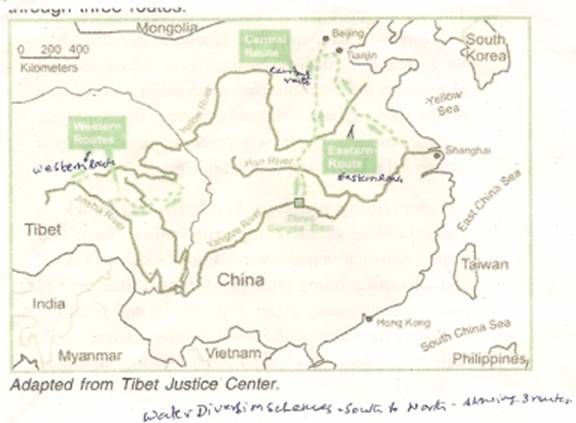
Chinese authorities tried to solve water problem of North China by harnessing yellow river (Source Amne Machan Glacier in Amdo, length 5464 kms, 1100 km in side Tibet). But due to high siltation (one kg silt in every cubic foot of water) its use is limited to power generation, urban consumption and industrial uses. Diversions for irrigation has reduced its flow. In 1997 it failed to reach the yellow sea for 226 days. This acute scarcity of water led to the diversion of Yangtse (Drichu) water to Huanghe along eastern route and central route (since completed). But it was found that Yangtse water alone would not be adequate to flush out/rejuvenate sluggish Huanghe and solve North China’s water problem. This impelled the Chinese leadership to launch the gigantic inter connected scheme of damming Yarlung Tsangpo (Brahmputra), Yangtse, Mekong and Salween and transfer their water to North China along the Great Western route. (Soutian)
The total cost of the three south to north water transfer scheme in 2002 was estimated at 180 billion Yuan (US $ 23 billion), 50% more than the total cost of the ‘Three Gorges’ the largest Hydro Power dam in the world. But the project costs keep getting bigger. When the great western route is completed it will be the biggest and most challenging water diversion project in history.
Brief Details of the Project
This project is known in PRC as the Great Western Route/South to North Water diversion scheme/Shoutian (Shoutian is a new Chinese word coined for a massive system of dams and canals caputuring water of all the major river of Tibet for diversion to Yellow River in North China in such quantity that water from Tibet would reach Tianjin, the Port City beyond Beijing, ‘Shou’ is the first syllable of SHOUMATAN, Gorge near Tsethang in Central Tibet where the first dam to intercept Yarlung Tsangpo will be built and TIAN is the first syllable of TIANJIN, the terminal point where the Yellow River merges in the Yellow Sea.
Purpose :-
The diversion canals / channels will span the whole of China from far South West Tibet to far North East China, The purpose is to raise water table of North China, flush out polluted Yellow River, increase its flow to make the deserts of north China in Mongolia, Manchuria, and Sinkiang bloom; drought proof whole of North China, dust proof Beijing, provide adequate Water for domestic, agricultural and Industrial use to the parched North.
Rivers whose water will be part of the River Diversion Project
Yarlung Tsangpo (Brahmputra) is the last free flowing river in Tibet – total length from Kailash Mansarowar to bay of Begal is 2897 kms. Length in Tibet 1625 kms, in India 918 kms (278 km in Arunachal and 640 km in Assam) and 354 kms in Bangladesh)
Yangtse – (Tibetan Name Drichu, Chinese Name-Chiang-Jiang) Source- Dhangla Range in Amdo province of Tibet, total Lenth 6308 kms (1100 kms in Tibet) world’s third Longest River, flows through Tibet and its Kham province, Yunan, Sichuan, Provinces of China and Central/ South China. 13 dams have already been built on this river including the Three Gorges dam—World's Largest and most controversial dam.
Salween :- Tibetan name-Gyalmo Ngul Chu, Ch.-Nu-jiyag, Length 2800 kms. approximately one thousand kms in Tibet flows through Tibet, Burma and Thailand
Mekong :- Tibetan name-Za-chu, Chinese-Langcang-Jiyang, Source-Amdo in Tibet, length-4500 kms. – 1500 kms in Tibet. Most international rivers of Tibet water six countries i.e. Tibet, Burma, Thailand, Laos, Cambodia, Vietnam and China.
The Site :-
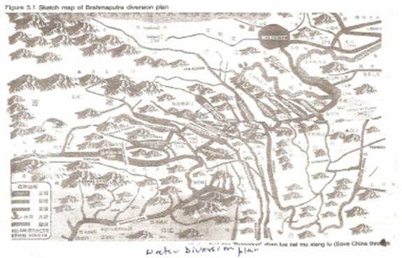
Accoring to the original plan Yurlung Tsangpo, (Brahamaputra) is to be dammed near the Great Bend in Pemako area where the Yarlung Tsangpo, after flowing due east for 1600 kms from its origin in Kailash Mansarovar, takes an abrupt south turn towards India near Pe in Kongo district of Tibet cutting through a very narrow and the deep Gorge between Namchan Barwa Peak (altitude 25445 above sea level) and Gyala Pheri Peak (alt. 23460’ above sea level ) This site is nearest to the Yellow River in Amodo (Chinghai in Chi.) where the Brahamputra water is to join the Yellow River. The Great Bend site was chosen because of its proximity to Yellow River and the steep descent of the Yarlung Tsangpo from 10000 ft. to 3000 ft. — a crucial factor for a hydro electrical dam. This site is also closest to Yangtse, Mekong and Salween rivers whose water are also to be captured and impounded with Brahmputra Water for diversion to Yellow River north ward.
The Route
Length of the route of the Canal from the damming site to the point where the diverted water will join Yellow River will be 1339 kms. Along the 1339 kms length of the route six mountain ranges will have to be tunneled amounting to total length of 56 kms of tunnels for channeling the captured water to Yellow river in North China, the original cradle of the Chinese civilisation. For blasting channels/tunnels through mountain ranges, controlled thermonuclear explosion may be used. Twisting fault lines and active tectonic slippage make the entire route earth-quake prone.
Besides many mountains gorges of Salween, Mekong, Yangtse, and Dadu river the mighty tributary of Yaingtse, will need to be crossed and dammed. Massive Pumping houses will need to be built along the way to lift water upward when the terrain is adverse and gradient steep.
The first dam on the Yarlung Tsangpo will be built near at Shouwmatan gorge near Tsethang in Central Tibet and then the last dam will be in Amdo Ngaba, between Amdo province and Sichuan Province, a remote and rugged pastoral region on the eastern most edge of the Tibetan Plateau. far above Dartsedo.
The pumped water will enter Yellow River at the junction of three Chinese provinces, where northern Sichuan abuts South Easten Chinghai and the Southern most prefecture of Gansu.
To minimize cost of construction of digging canals, The natural down flow of the route along existing valley floors lie of the land will be utilized/. This would submerge farming valleys. Submergence of the farm land and villages is the most vulnerable part of this project. Hundreds of thousand of Tibetans might be displaced from their homes/villages which will be sub merged to by the dams and canals. Human and ecological cost of the project will be enormous.
Storage ponds
The captured/impouned and diverted waters of Brahmputra, Yangtse, Mekong, and Salween will make four fold increase in the yellow river water. It is feared that after this four fold increase Yellow river might break its bank, and devastate north China with flood.
Many storage ponds will be required along the route. Tibet’s biggest lake, Tso Ngonpo (Mongolian – Koko Nor, Ch.-Qinghai Hu) will be the most enormous storage pond for the entire scheme. The level of Tso Ngonpo has been falling slowly and steadily for thousands of year. The dried shore of the lake is used for farming. After the captured water of Bharmputra etc. are brought to the lake for storage the lake level will rise by 35 meters, which will flood a lot of fertile farm land. Only one quarter of the Tibetan water pumped into Tso Ngonpo would then flow in to the Yellow River.
Other storage pond areas are also planned in Amdo, Lajia in Machen County. This will drown pastures.
Whole of Amdo Province will be turned into a vast pumping and Storage system to handle the ponded and redirected water. Managing it enroute to China will in itself be a very complex task.
Adverse Effect of Diversion :-
The scheme, if implemented will adversely impact on water resources of India , Bangladesh, Thailand, Burma, Laos, Combodia, Vietnam, Tibet and ‘Provinces’ of South China. Human cost will be immense. Lakhs of people will be displaced; farm lands, villages, pastures will be sub-merged. The dam site near Great Bend is in seismic Zone. In case of natural earth-quake or pressure of dammed water induced earth quake have serious consequences for the lower riparian India and Bangladesh.
Genesis of the Brahmputra Water Diversion Scheme :-
Diversion of Tibetan river waters to North China is not a new idea. Mao had the vision in 1950 when Communists captured power in China, to connect Lhasa with Beijing by Rly Line and transfer free flowing Tibetan river waters to North China. Due to daunting technological difficulties these ideas could not be implemented then. When technology improved Rly. Line to Lhasa was taken up in 2002 and this technological and engineering marvel was completed in 2006.
The Brahmputra project is said to have caught the fancy of PLA in 1988 and a preparatory committee was set-up. In 1998 when China faced a serious water crisis, President Jiang Zemin approved the idea in principle. He ordered a survey by scientists to examine technical / scientific feasibility of the scheme. A 11-member survey team of scientists / Engineers / Mountaineers surveyed the Great Bend area in 1999 with the help of local Monpas of Pemako with great difficulty. They found the narrow gorge between Namcha Barwa in Gyalapheri the deepest in the World, the river very volatile and area formidably difficult surrounded by 5 km. high stone walls of Namcha Barwa and Gyalapheri on all sides. Based on their report, its claimed, the State Council, PRC’s Highest State Institution, accorded its approval to the scheme, it is claimed.
In March 2007, 100 billion Yuans were sanctioned for 180 unnamed projects in Tibet to be undertaken by 2010. It was suspected that these projects included Barhmputra scheme’s advance preparation .
The National Remote Sensing Agency (NRSA) of India confirmed this year (2010) that the work on the Brahmputra Diversion site has started in the Great Bend Area of Pemako. In a presentation made to the Committee of Secretaries, the NRSA presented evidence suggesting construction activities, excavation, movements of trucks in and around the Great Bend area in Pemako and Zangmu areas near Tsethang. The dam is being built in Namcha Barwa area close to India’s border. It is estimated to cost US$ 60 billion. The cost is likely to go up. It will be the largest dam and water diversion project in human history. It will also generate 40 million KW/hr of hydro electricity with 26 turbines.
Zangmo Hydroelectric project was inaugurated on March 16, 2009.
At the moment it is not clear if the current dam project on Brahmputra at the Great Bent is merely a run of the river hydro-power project, as claimed by China, or part of the South-North water diversion project. China is unlikely to clarify it in unambigoons terms.
The Great Bend Area
The Great Bend contains within it the areas of LHO Tekha, Pemoka and Chimdru. It is South of the major Himalayan Water Shed. It was a sort of No Man’s Land upto 1962, when Chinese occupied it. The Original inhabitants of this area were Lobas i.e. Tangam and Abors of India. A Loba to a more sophisticated Tibetan is what a pagan was to a Christian, barbarian to Roman, savage/heathen to a Greek. The present inhabitants of Pemako are Monpas. They are different from the Tibetans in appearance, hair style, dress, food habits and language. They came to Pemako in search of a promised land from Drugyul and monyoul of Bhutan in the 19th Century. They purchased/took on lease land from the Lobas (Indian Tangams and Abors) in Pemako. In due course they assimilated / elbowed out the Lobas to the south to Tuting area in Siang District of Arunachal.
India had close, friendly relations with Tibet when Tibet was independent. The Indo-Tibet border was peaceful. There was no need to guard it. The frontier area was also formidably difficult and it was prohibitively expensive to maintain posts there. There was no administrative, revenue or police post within 100 miles of the Tibetan border. When the Chinese occupied Tibet, the situation changed dramatically and it was decided by Govt. of India that it would not be prudent to leave vacuum in the sensitive frontier areas and Indian Officers were sent to explore the frontier area and setup posts. I, as a young officer, had the privilege and challenge of exploring the frontier areas of Arunachal and setup posts. One of the posts setup by me was at Korbo on the McMahon Line where Tsangpo enters Indian territory as Siyang river. A representative delegation of the people of the Great Bend area of Pemako, Chindru, Loteka consisting of leaders of the areas including Village-Chief, Incarnet Lambas, farmers, graziers, hunters, lay and monastic people, submitted (1960) written representation addressed to Govt. of India to take over Great Bend Area of the Pemako etc. under Indian Administration as the area belonged to Indian Lobas from whom they had acquired the land on Lease /Sale in exchange of Mithun, Swords, Bhutanese Raw Silk. They brought original sale / lease deeds on hand made papers with signature and seals in support of their claim that they had taken this land from the Tangams and Abors of India who were the original inhabitants and that their descendents were still living in Tuting sub division of Indians across the border. Representation was sent to Govt. of India, but was not acted upon as repudiating the Mcmohan line might provoke strong reaction from the Chinese.
Tibet is the principal water shed of Asia and source of its prime rivers. These rivers sustain the economy and life of these countries where almost half of the human race, (47% of world population) resides. The rivers originating in Tibet are the common heritage of the Asian countries through which they flow, and have lower riparaian rights.
Steep slopes and abundant river flows give Tibet an exploitable Hydropower potential of 250000 mega watts. Exploitation of fresh water resources of Tibet is an integral part of China’s macro level resource management. China is doing this under :-
i. South-North Water diversion Project under Shoutian Scheme by damming all major rivers of Tibet in an interconnected scheme. (discussed in the preceding pages of this paper.)
ii. ‘West to East power Transmission’ scheme through Integrated National Power Grid. Under this scheme China has gone on a spree to build innumerable cascade of dams and mega hydro dams in the Tibetan plateau and on its edges. Under this scheme Mega dams like the ‘Three Gorges dam’ (The largest in the world) ‘confluence of two rivers dam’, ‘Tiger Leaping Gorge Dam’, ‘Yeti Lake Dam’ (Mega Tso), ‘Yamdrok Yutso Dam’,’ Renzongghai Lake Dam’, ‘Longyong Xia Dam’ etc. have been built.
The number of dams constructed /under construction are said to be as fellows:
Name of the River Constructed / under Construction
1. Yangtse
river - 63 / 101
2. Huangho
river - 40 / 47
3. Mekong
river - 22 /25
4. Salween
river - 13
5. Gyarong Mgulchu
- 48 / 356
(Ch.-Dadu)
-
6. Yarlung Tsangpo - 3
7.
Indus - 3
PRC is the greatest dam builder in the world. Since October 1949, it has built 85000 dams of which 22000 are large dams.(there are 45000 large dams in the world.)
The main question at present is the nature of the dam being built on Yarlung Tsangpo (Brahmaputra) at the Great Bent. China claims that its run of the river dam is for power generation and will not affect the lower reparaian rights of India. Despite the existing mechanisms on sharing of hydrological data, the Chinese tend to be less than forthcoming about their schemes and intent. the fact that a South-North Water Diversion Project officially exists, is a cause of worry for all the lover ripparains as it affects India, Bangladesh, Myanmar, Laos Vietnam and Thailand. The traditional Chinese opaquences and confusing signals are a matter of anxiety. India and other countries should closely monitor the developments and if possible, interact with China to make it more open on these issues.